Image GIS Registration
Mayachitra's geo-registration capability creates seamless geo-referenced panoramas, as it is able to utilize a set of ground control points provided by the image analyst to bootstrap the georeferencing process.
 Mayachitra Inc. has developed technology to quickly create an accurate georeferenced map using the latest images taken from airborne platform. We incorporates new and powerful georegistration capabilities to create seamless georeferenced panoramas, and the newly registered images will inherit the latitude and longitude information from the reference images. There is no need for ground control points. If the images are not georeferenced, our technology is able to utilize a set of ground control points provided by the image analyst to bootstrap the georeferencing process. In both cases the final results is the same: a seamless, accurate, and georeferenced panorama that can be imported by all the most popular GIS software suites.
Try out AIPR LITE-1 an Image registration software developed by Mayachitra
Mayachitra Inc. has developed technology to quickly create an accurate georeferenced map using the latest images taken from airborne platform. We incorporates new and powerful georegistration capabilities to create seamless georeferenced panoramas, and the newly registered images will inherit the latitude and longitude information from the reference images. There is no need for ground control points. If the images are not georeferenced, our technology is able to utilize a set of ground control points provided by the image analyst to bootstrap the georeferencing process. In both cases the final results is the same: a seamless, accurate, and georeferenced panorama that can be imported by all the most popular GIS software suites.
Try out AIPR LITE-1 an Image registration software developed by Mayachitra
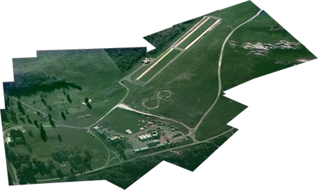
Seamless (non georeferenced) panorama from 617 frames of the videos taken over Fort A.P. Hill, VA

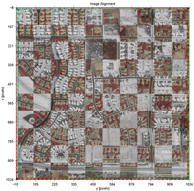
Georeferenced panorama which utilizes the ground control points provided by the analyst for 3 video frames to geo-register remaining 614 frames from a video clip to the referenced image.
The team is currently working on extending the methods for multi-modal data, including IR to EO imagery, and EO to SAR data, for various defense applications.